Efficiency and accuracy are important, especially for individuals in fields such as civil engineering, land surveying, architecture, and construction. That’s where SpotLens comes into play. SpotLens is a powerful Android camera app specifically designed for professionals in various industries. With its unique features and capabilities, this app simplifies the process of capturing photos on-site while seamlessly adding important information and timestamps through a watermark.
Features of SpotLens App
Efficient Note-taking
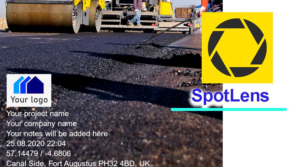
One of the standout features of SpotLens is its ability to combine photography and note-taking in a single app, eliminating the need for separate processes. With SpotLens, professionals can capture photos directly within the app while simultaneously adding essential information to the file name and photo using a customizable watermark. This streamlines the workflow, allowing users to focus on their work rather than juggling between taking notes on paper and capturing images.
Comprehensive Data Integration
SpotLens goes beyond basic note-taking by automatically integrating relevant data into each photo. Users have the flexibility to add project names, company names, and detailed notes directly within the app. Moreover, SpotLens enriches photos with additional data such as GPS coordinates (latitude and longitude), GPS accuracy, altitude, address, date and time (timestamp), compass direction, customized company logos, and reference numbers or chainage. This comprehensive data integration ensures that every photo is embedded with critical information, enhancing documentation and facilitating better analysis.
Versatility in Coordinate/Grid Systems
For professionals relying on specific coordinate or grid systems, SpotLens provides extensive support. This app seamlessly integrates with a wide range of coordinate/grid systems, including WGS84 (latitude and longitude), UTM, MGRS (NAD83), USNG (NAD83), ETRS89, ED50, RD (RDNAPTRANS2018), British National Grid (OS National Grid), Map Grid of Australia (MGA2020), Irish Grid, Swiss Grid CH1903+ / LV95, and New Zealand Transverse Mercator 2000 (NZTM2000). This versatility ensures accurate and consistent data representation across various geospatial contexts.
Applications Across Industries
SpotLens caters to professionals across diverse industries. Land surveyors can leverage its features during surveys, construction site visits, and general land surveying tasks. Civil engineers involved in road engineering and highway design can benefit from adding chainages to their photo information. Architects can utilize SpotLens to document construction progress effectively. Geologists can rely on SpotLens as a reliable work camera app for field surveys and documenting findings. Real estate agents and professionals can streamline their work processes by using SpotLens for real estate and housing documentation. Ultimately, SpotLens is a valuable tool for any professional seeking to enhance their photo documentation and note-taking efficiency.
Install SpotLens on Android
SpotLens camera stands out as a powerful Android camera app designed to cater to the unique needs of professionals. You can use Google play store application to install this Android camera app for free.
This camera app does not have filters and effects for beauty camera apps. This is for professional work only. You can use camera apps like B612 to capture beauty selfies and photos. Download B612 apk today and enjoy beauty photos without needing to edit.